
%401x.png)

On any given construction project, the general contractor (GC) and the capital project owner are bound by a common goal: to deliver a high-quality asset on time and on budget. Yet, despite this shared objective, the relationship is often defined by friction, misaligned expectations, and a frustrating lack of transparency.
Think about the last time a project hit a snag. A GC, working diligently off the latest set of drawings, discovers a conflict only after work is in place. An owner, who made a last-minute change they assumed was communicated, is surprised by a two-week delay and a costly change order.
This isn't an isolated incident; it's a consistent problem. These disruptions erode trust, inflate budgets, and tarnish reputations. The numbers tell a sobering story: research from the Project Management Institute (PMI), shows that poor communication is the primary reason why one-third of construction projects fail. When you consider the complexity and amount of collaborators on a single project, it's easy to see how crucial information gets siloed.
The tide is turning. Today, owners are no longer content with weekly progress reports and a handshake. A high number of GCs agree that their clients are looking for greater transparency into key project data. They are demanding real visibility on their multimillion-dollar investments and are getting more involved.
The challenge lies in bridging the information gap. How can GCs effectively communicate the complex, day-to-day reality of the job site to an owner who isn't there daily? How can owners gain the confidence that their money is being spent on verified, completed work? How can both parties access the critical data they need to plan and operate better, whether during or after the construction project?
When communication relies solely on dashboards, written reports and static photos, verifying these critical points becomes a matter of trust.
But what if you could replace "trust me" with "show me"?
This is the promise of spatial intelligence.
Let’s dive in.
Spatial Intelligence: A Single Source of Truth
Let’s start off with a baseline definition:
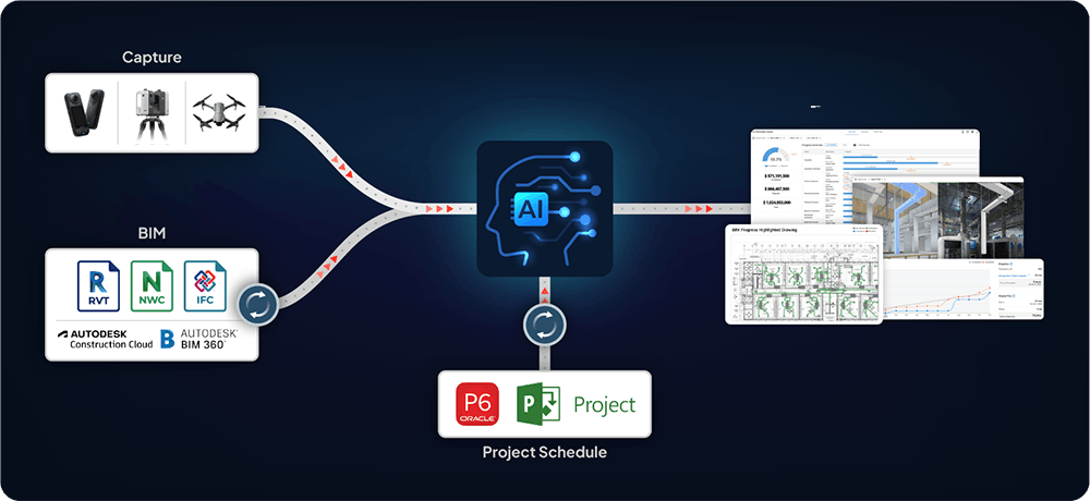
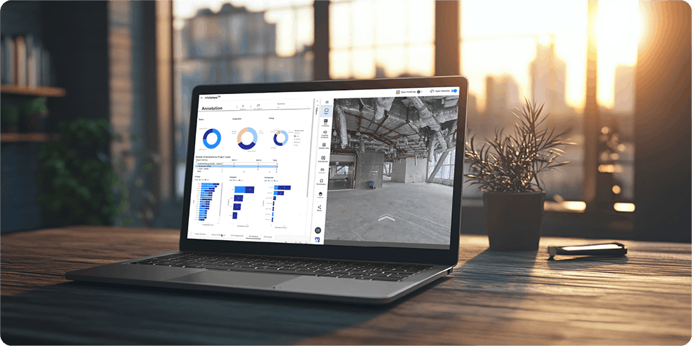
At its core, spatial intelligence is a system that centralizes BIM data, 360° site photos, and other reality capture data into one platform. Using artificial intelligence (AI), the platform doesn't just store this information, it understands it. It automatically stitches together captures to create a comprehensive, 3D as-built representation of your site.
As you capture new data over time, it builds a complete visual timeline, allowing you to virtually step back in time to any point in the construction process. AI analyzes what it sees, compares it to your plans, tracks progress, and identifies potential issues, creating a single source of truth that both the GC and the owner can rely on.
The bottom line: Spatial intelligence provides dynamic, accurate insight into your building's actual condition across its entire lifecycle.
It Works: Simple Capture, Powerful Insights
The process is remarkably straightforward and designed for the speed of construction and operations.
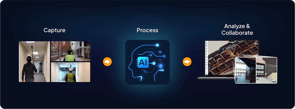
- Capture: A team member walks the site with a consumer-grade 360° camera, recording video. There's no need for complex setup or strict capture guidelines; a normal site walk is all it takes. Capturing an entire floor can be done in minutes, not the hours or days required for traditional laser scanning.
- Process: Once the video is uploaded to the platform, AI processes the spatial data, automatically aligning it in 3D, and integrating the new visuals into the project timeline.
- Analyze & Collaborate: Within hours, an updated, interactive 3D view of the site is generated. You can compare as-built conditions to your BIM model, track the percentage of work completed by trade or area, and share specific views and insights with your stakeholders.
What makes spatial data intelligent is the ability to find the insights you need faster and act on them.
Here is an example of how this plays out in real life:
- Let’s say an owner wants an update on how the project is tracking against the schedule.
- Instead of sending messages back and forth for hours to get progress updates, the GC or owner can access progress updates immediately.
- The owner can see exactly where progress stands through time-stamped panoramic photos and 3D documentation, which helps them know the real status of their project.
Spatial intelligence allows you to track progress in a way that is accurate and actionable, making sure you come in on time and on budget, built as specified.

The Benefits of Spatial Intelligence Tools
This approach delivers four key benefits that fundamentally transform the owner-GC dynamic:
- Speed & Automation: The process is so fast it doesn't disrupt fieldwork. GCs receive actionable data back quickly, automating the documentation process and freeing up their team to focus on building. Owners can speed up time to respond to RFIs based on site conditions ensuring GCs can get back to work quicker.
- Alignment: No more debates over progress. Owners and GCs can visually verify whether the BIM model aligns with what has been built, address any issues before it leads to rework, and understand how progress tracks against the schedule.
- A Single, Actionable Source of Truth: All 3D lives in one place. This creates an irrefutable record during construction and becomes an invaluable digital twin for the owner during operations.
- Connection & Accessibility: With remote access, owners can virtually walk the site from their office anywhere in the world. This saves everyone time, reduces travel costs, and keeps stakeholders connected to the project's reality.
Spatial Intelligence Across the Project Lifecycle
The true power of this alignment is realized when it's applied from day one through to handover. Let's walk through how GCs and owners can collaborate more effectively at each project phase.
Phase 1: Planning and Preconstruction – Building a Foundation of Trust
Collaboration begins long before the first shovel hits the ground. During preconstruction, an initial site scan can create a detailed 3D model of existing conditions. This allows for more accurate takeoffs and helps identify potential issues that weren't obvious from the original survey, such as unexpected grading requirements or clashes with existing structures.
Utilizing a comprehensive scan sets a standard of transparency and trust and lays the foundation for a collaborative partnership between. Both parties are able to see the real-world conditions from the start, not just an idealized site plan.
Phase 2: Construction – A New Era of Transparency and Quality
During the construction phase, spatial intelligence becomes the central hub for documentation, quality control, and progress tracking.
Comprehensive Site Documentation
A comprehensive visual timeline of the project is invaluable for documenting work-in-place, especially for elements that will eventually be covered up. For an owner, this record is gold. Years later, when they need to perform maintenance or a renovation, their facilities team will have a perfect, x-ray view of what’s behind the walls, including the exact location of MEP runs and structural components.
This approach gives the general contractor full control over the project's narrative. They can provide owners with controlled access to specific site views and progress updates, guiding them through the project's evolution in a clear and organized manner. This level of transparency and control prevents "surprise visit" panics, where an owner might show up unannounced during a messy phase and mistakenly assume the project is chaotic or off-track. The documentation also serves as the ultimate protection for the general contractor, offering time-stamped visual proof of completed work, which helps resolve potential disputes before they can escalate.
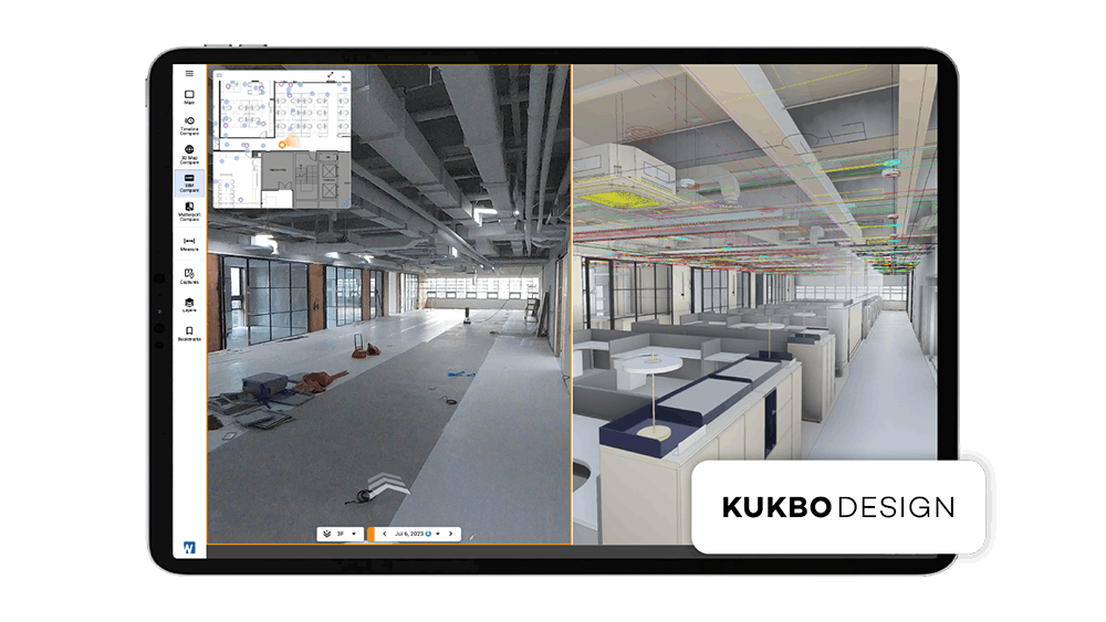
Take the example of Kukbo Design, by implementing Cupix, they were able to automate their site documentation process, which significantly enhanced remote project management and collaboration across its geographically dispersed sites. This transformation resulted in a 50-66% reduction in site visits and a 50% decrease in documentation errors, while improving payment verification acceptance rates by an average of 60%.
Dynamic BIM Collaboration and Quality Control
We all know the BIM model is a living document. The real challenge is identifying deviations between the model and the as-built reality before they become costly rework. Spatial intelligence automates this process. AI native to the application compares reality captures to the 3D model and exposes discrepancies. This serves as an early warning system for potential conflicts.
This capability is a game-changer for GC-owner collaboration. When an owner requests a change, for example, splitting a large conference room into two smaller offices, the GC can immediately show them the real-world implications. The tool can overlay the proposed design onto the existing conditions, revealing how the change impacts MEP, structural elements, and finishes.
Furthermore, this makes the BIM model accessible to non-technical stakeholders. An owner can virtually walk through the coordinated model in the context of the actual site, gaining a true understanding of the space. This clarity dramatically reduces RFIs and late-stage change orders born from misunderstanding 2D drawings.
Visual and Verifiable Progress Tracking
This is the ultimate win for owners. Instead of a line item in a report stating "electrical rough-in is 60% complete," owners can see it for themselves. With a few clicks, GCs can generate a color-coded visual report highlighting the areas that are complete or in progress, and which have yet to begin.
GCs can also create instant progress comparisons by overlaying the BIM model—showing what should be done by a certain date—with the reality capture of what is actually complete. This provides an undeniable, data-driven view of where the project stands.
Phase 3: Handover & Operations – Delivering a Lasting Asset
The final sprint to project completion and handover is often fraught with delays in compiling as-built documentation. With spatial intelligence, this process is revolutionized.
The moment the project is complete, GCs can hand the owner a digital as-built, 3D record of every phase of construction. This "digital twin" is an incredibly powerful asset for their facilities management team. It eliminates guesswork, streamlines maintenance, and provides invaluable data for planning future renovation. In addition, the comprehensive documentation minimizes unplanned downtime and helps extend the lifecycle of an owners’ facilities.
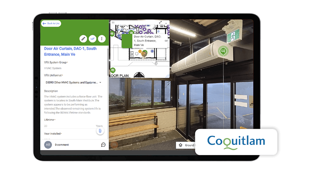
Take the example of The City of Coquitlam which prior to adopting Cupix did not have a clear picture of all the assets in their facilities despite having a maintenance management and capital planning tool. After adopting Cupix, Coquitlam increased the number of recorded assets by up to 49%, shining a light into the true number of assets in their facilities and their conditions. With Cupix, Coquitlam was able to streamline maintenance operations and reduce the number of site visits allowing the teams to resolve issues that could be addressed remotely. Coquitlam was ultimately awarded the Canadian Network of Asset Managers Innovation Award because of the positive impact realized by adopting Cupix’s spatial intelligence platform.
The Future is Collaborative
The construction industry is at a crossroads. As projects are growing more complex and owners expect greater transparency, the old ways of working, with their information silos and adversarial relationships, are no longer sustainable.
Spatial intelligence offers a clear path forward, transforming the dynamic between general contractors and owners. It replaces the periodic updates and “trust-me” conversations with real-time collaboration and a shared, verifiable understanding of project status. This change not only provides a competitive advantage but fundamentally shifts the relationship from transactional to truly collaborative.
Want to learn more about this topic? Click here to read about Cupix’s proprietary spatial intelligence platform – CupixWorks.
And if you're ready to see how AI-powered spatial intelligence can transform your projects and align your teams, schedule a personalized demo with our experts today. Let's build better, together.

